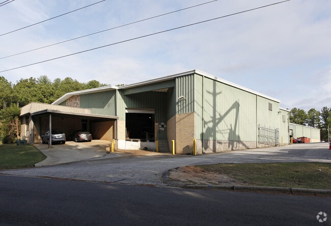
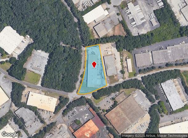
Property Record
305 Selig Dr Sw, Atlanta, GA 30336
NEARBY LISTINGS FOR SALE OR LEASE
Property Detail
305 Selig Dr Sw
Warehouse
Fulton
X
Georgia
13121C0331F
2.29 AC
2024
Fulton District
2025
Atlanta
007805
Atlanta-Sandy Springs-Roswell, GA
17,844 SF
14F-0083-LL-022-0
DEMOGRAPHICS near 305 Selig Dr Sw
1 Mile
3 Mile
5 Mile
2024 Total Population
668
42,610
122,137
2029 Population
690
43,896
126,301
Pop Growth 2024-2029
+ 3.29%
+ 3.02%
+ 3.41%
Average Age
40
37
38
2024 Total Households
285
16,824
47,577
HH Growth 2024-2029
+ 3.51%
+ 3.13%
+ 3.48%
Median Household Inc
$52,250
$53,359
$58,662
Avg Household Size
2.30
2.50
2.50
2024 Avg HH Vehicles
2.00
2.00
2.00
Median Home Value
$287,179
$223,480
$255,604
Median Year Built
1982
1983
1984
Nearby Places
Map Layers
Map Styles
 Street
 Aerial
- Restaurants
- Banks
- Shops
- Fitness
- Groceries
PUBLIC TRANSPORTATION
AIRPORT
Hartsfield - Jackson Atlanta International
DRIVE
WALK
Distance
Hartsfield - Jackson Atlanta International
30 min
19.1 mi
SALE & LEASE HISTORY
LISTING DATE
SALE/LEASE

Feb 07, 2017
For Sale
Apr 12, 2017
For Sale
Nearby Properties
Address
Land Use
TOTAL SIZE
Lot Size
Zoning
Address
Land Use
TOTAL SIZE
Lot Size
Zoning
454,000 SF
68.17 AC
LI-R
Address
Land Use
TOTAL SIZE
Lot Size
Zoning
Address
Land Use
TOTAL SIZE
Lot Size
Zoning
830,966 SF
23 AC
MIXU
Address
Land Use
TOTAL SIZE
Lot Size
Zoning
652,500 SF
52.87 AC
LI-R
Address
Land Use
TOTAL SIZE
Lot Size
Zoning
913,620 SF
58.88 AC
Address
Land Use
TOTAL SIZE
Lot Size
Zoning
603,096 SF
38.38 AC
HI
Address
Land Use
TOTAL SIZE
Lot Size
Zoning
6,603,740 SF
24.69 AC
RG3
Address
Land Use
TOTAL SIZE
Lot Size
Zoning
290,784 SF
21.09 AC
RM-12
Address
Land Use
TOTAL SIZE
Lot Size
Zoning
732,688 SF
47.23 AC
LI-R
Address
Land Use
TOTAL SIZE
Lot Size
Zoning
283,396 SF
29.88 AC
RM-12
Address
Land Use
TOTAL SIZE
Lot Size
Zoning
814,536 SF
37 AC
R3
Address
Land Use
TOTAL SIZE
Lot Size
Zoning
540,000 SF
35.76 AC
DCD
Address
Land Use
TOTAL SIZE
Lot Size
Zoning
523,551 SF
50.93 AC
LI
Address
Land Use
TOTAL SIZE
Lot Size
Zoning
1,825,146 SF
16.16 AC
RG3
Address
Land Use
TOTAL SIZE
Lot Size
Zoning
567,480 SF
44.13 AC
LI
Address
Land Use
TOTAL SIZE
Lot Size
Zoning
70.12 AC
Address
Land Use
TOTAL SIZE
Lot Size
Zoning
241,200 SF
18.40 AC
RM-12
Address
Land Use
TOTAL SIZE
Lot Size
Zoning
395,218 SF
21.61 AC
A1
Address
Land Use
TOTAL SIZE
Lot Size
Zoning
479,591 SF
29.76 AC
LI-R
Address
Land Use
TOTAL SIZE
Lot Size
Zoning
729,946 SF
34.07 AC
M2
Address
Land Use
TOTAL SIZE
Lot Size
Zoning
70.35 AC
R3
Address
Land Use
TOTAL SIZE
Lot Size
Zoning
1,994,368 SF
17.10 AC
ACOND
Address
Land Use
TOTAL SIZE
Lot Size
Zoning
498,167 SF
11.18 AC
HI/WS
Address
Land Use
TOTAL SIZE
Lot Size
Zoning
448,314 SF
32.13 AC
DCD
Address
Land Use
TOTAL SIZE
Lot Size
Zoning
1,333,625 SF
15.28 AC
A1
Address
Land Use
TOTAL SIZE
Lot Size
Zoning
283,585 SF
22.75 AC
LI
Address
Land Use
TOTAL SIZE
Lot Size
Zoning
77.30 AC
M2
Address
Land Use
TOTAL SIZE
Lot Size
Zoning
311,073 SF
56.51 AC
LI
Address
Land Use
TOTAL SIZE
Lot Size
Zoning
152,348 SF
12.76 AC
RM-12
Address
Land Use
TOTAL SIZE
Lot Size
Zoning
350,840 SF
22.90 AC
LI
The World's #1 Commercial Real Estate Marketplace
Connect with us
© 2025 CoStar Group
The information above has been obtained from sources believed reliable. While we do not doubt its accuracy we have not verified it and make no guarantee, warranty or representation about it. It is your responsibility to independently confirm its accuracy and completeness. Any projections, opinions, assumptions, or estimates used are for example only and do not represent the current or future performance of the property. The value of this transaction to you depends on tax and other factors which should be evaluated by your tax, financial, and legal advisors. You and your advisors should conduct a careful, independent investigation of the property to determine to your satisfaction the suitability of the property for your needs.